Tranquility

Tranquility
Sunset in a Senegalese Village

Monday, August 22, 2011

So will this be the science fiction movie -- IRENE takes the East Coast by Force??


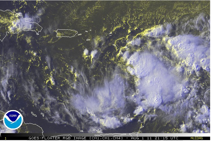
So, once again, Mother nature teaches us a thing or two. Yesterday, Hurricane Irene was forecast to to go west and pass over the Dominican Republic or Haiti. However, a strange thing happened along the way-- It went north and crossed over Puerto Rico knocking out power to half of the country. That in turned changed by the track and intensity of Hurricane Irene. Why??

If Hurricane Irene had gone across the Dominican Republic- the mountains would have weakened it. As it turns it turns out, Irene has not weakened and the track is carrying it up the East Coast. The models (global and mesoscale) are converging on this solution.

But what if some of these model solutions are correct --

Hurricane Irene will be powerful Category 3 that roars into the Carolinas but then hugs the coast spreading havoc up the coastline and then making a second landfall in NYC???? Does this seem like a crazy scenario??

Well hurricane have made landfall on Long-Island and also struck NYC. Unfortunately, nature does not know that these are modern cities where people feel comfortable. It also does not know that tens of millions of people live along the coastline where they drive the US economy.

The real danger is that is virtually impossible to evacuate DC, Philly, NYC, Boston. There is not enough road. In addition, our infrastructure has not been tested for many years now and we are more connected -- by phone towers, power lines, gas lines -- a failure of one system impacts other systems and many people all at once. So while I hope that scenario does not play out, we should accept that we are not flexible and probably not prepared for the worst case scenario. In a bad scenario, those who have less will lose the most. Those who are most vulnerable will lose the most.

Even if climate change were never to happen, it is an eventuality that a strong hurricane will one day hit a major population center. The urbanization will not work in our favor. I think that Hurricane Rita taught us that in 2005.

In the meantime, stay aware of the threat and be ready to go outside of your comfort zone if it is required. That may mean stocking up on canned items and water even if this is not the worst case scenario. Make a list of all of those people that you might have to help or at least make sure that they are safe. Make a list of all of those important items that you might need to take with you (prescriptions, cash, passports, birth certificates, bank account numbers) It never hurts to be prepared.


Sunday, August 21, 2011

Potentially Dangerous Irene on the move. Who is vulnerable??


TS Irene continues to develop this afternoon and is currently located just to the southeast of Puerto Rico. She is under very favorable conditions (an upper level anticyclone, low shear and warm waters) for rapid development over the next few days. The models are split on the path of where she is going. The last GFS and Canadian models carry Irene towards Miami and the East coast of the US. Some of the mesoscale models are carrying it towards Western Florida. In all cases, the models are developing a Hurricane that will be Category 2 or higher on its way to the US.

Before that happens, the next 48 hours will determine how Irene evolves. Depending on how much interaction there is with Dominican Republic and Haiti will determine the strength of Irene. The more it interacts with the high mountains the weaker is will emerge. However, little or interaction with the mountains will mean a stronger system will head towards the United States.

In any case, whether you are in southern parts of Puerto Rico, San Domingo, Port Au Prince, Nassau or Miami, or other areas you need to stay tuned and be prepared to move if necessary. Identify your key personal items (bank accounts, passports...) and get cash if the forecast is for a landfall in your area. The biggest threats in the next 48 hours will be to Puerto Rico, Dominican Republic and Haiti from live-threatening rains and possible Category 1 winds. Later (Wednesday -Saturday), the threat will be over the US and possibly the Bahamas.

2 PM location (from the Hurricane Center)
----------------------------------------------
LOCATION...17.5N 63.7W

ABOUT 70 MILES...115 KM...ESE OF ST CROIX
ABOUT 185 MI...300 KM ESE OF PONCE PUERTO RICO
MAXIMUM SUSTAINED WINDS...50 MPH...85 KM/H
PRESENT MOVEMENT...WNW OR 290 DEGREES AT 18 MPH...30 KM/H
MINIMUM CENTRAL PRESSURE...999 MB...29.50 INCHES

The pressure has fallen by and estimated 6 mb since 11 AM -- suggesting strengthening.


Saturday, August 20, 2011

Is this the ONE??? -- TC IRENE


Well another threat to the Caribbean exist today. Thus far the cyclones have all been tropical storms with the models having trouble with their intensity. However as we continue to roll into late August and September, the water temperatures will warm lagging behind the air temperatures. But the lastest disturbance looks nasty and the global models are all forecasting it to become a significant hurricane. The tracks vary from crossing Haiti to Cuba with an eventual track towards Florida or the Gulf of Mexico. Many models are forecasting it to strengthen rapidly once it crosses the leeward Islands, but I suspect that they will catch some very bad weather over the next 48 hours.

Hey its August 20 and we are at storm name Harvey. My friends and colleagues in Cape Verde were under the influence of a strong wave today. It may also develop -- but watch out for 3-4 days from now with a very strong wave is forecast to cross Dakar and roll into Cape Verde. Looks like its getting busy out there. Next 15-20 days will tell us a lot about the 2011 hurricane season.


Sunday, August 14, 2011

A case study of Haiti and TS Emily --- Model Uncertainty or a stroke of divine intervention


Tropical Storm Emily while forgotten remains an enigma. First, this was a storm that played havoc with intensity forecast and also location. The most amazing piece of the story is with Haiti. The storm had been slowly moving towards Haiti with our worst fears coming to mind. However, we were told that there were 12,000 UN peacekeepers were ready to help those living in flood-prone areas where people were living in tent cities. The rain was heavy to the neighboring Dominican Republic just to the east.

But not so fast. A strange things happened along the way. The tropical storm completely dissipated just before hitting Haiti. Crazy thing is that is regenerated to the north of Cuba a day or so later. So what in the world ...... Well this was a storm that was a mess to forecast at any rate. There were difficulties in figuring out the real location was at as soon as it came into the Caribbean Sea. When it was forecast to turn north it didn't. This one will be a case that scientists will try to simulate to see what happened. On the other hand, some would say that it was divine intervention. If it was I say Thanks to God because it was looking very bad for heavy life-threatening rains over Haiti.

There are two take away points -- One models that we use are not perfect and although there are right the majority of times, there are still many uncertainties about tropical cyclones. The second takeaway point is that just because an area did not get hit does not mean that you should let your guard down. Those who are vulnerable need to be made less vulnerable and everyone needs to have some degree of preparing if you live in a land-falling zone. The next 8 weeks are when historically most of the tropical cyclones occur.

We have had 7 named storms thus far. This time last year we had 3. We had 19 named storms in 2010. Right now there are significant amounts of dust over the Eastern Atlantic that should keep tropical storms down in that part of the Atlantic. But just because the African Easterly Waves do not immediately form tropical cyclones should not make you think that they are not there. We can track these waves across the the Atlantic and sometime they have organized thunderstorms and sometimes they do not. But if the right conditions should arise, genesis of a tropical cyclone is possible.

So, stay prepared and don't drop your guards.

Tuesday, August 2, 2011

TS Emily -- A case of mistaken identity --Prepare Haiti


Last night at 7:30 PM TS Emily was officially named for the disturbance in the tropics. The hurricane hunters had identified a well defined disturbance and it was to the east of the Island. I believe that they did, but was it one of multiple vortices that were spinning off the main system?? I believe that it was and immediately all concerns went to what was happening to the north of the system.

However, I do not believe that the real center was identified because if it had been, it should not still be raining in St. Lucia with is closer to 14 N and far to the east of where the system would be. Based on satellite pictures from early this morning the storm had reorganized to the east of the islands and dumped significant amounts of rain on most of the windward Islands. So hurricane genesis is difficult and with one plane investigating a large area is is very difficult.

This morning there is dry air to the north which may be the reason why the TS Emily looks asymmetric with no rain bands to the north. Most of the models are keeping TS Emily as a weak tropical storm and the GFS is actually has it degenerating to a weak easterly wave. However, it the models are using last nights fix for the location of the storm then they could all be biased also. Caption: Dry air to the North of TS Emily (denoted in orange)


At any rate, even if it remains a tropical storm and the path takes it over Haiti it could be damaging to the people living in the tent cities. The next 24-48 hours will determine how much danger the people of Haiti will be in. The system still appears to be healthy this morning and could strengthen as the day goes on. Hopefully the flooding was not so bad in the islands last night and this morning.


Monday, August 1, 2011

TO WARN OR NOT TO WARN in the face of uncertainty during Crop Over


The past weekend and today was Crop Over -- it is the Carnival of Barbados. Lots of costumes, music and fun. People fly in from all over for Crop Over for the experience of being there. Of Course it was extra special this year because Rihanna returned home and was in the parade!! The only damper on crop over was a tropical disturbance that was located about 200 miles northeast of Barbados this morning. There was anticipation that a tropical depression would form but the timing was not clear. This morning the storm looked disorganized and the hurricane hunters did not find a closed circulation. However, this afternoon a strong band of convection began heading towards Barbados. Of course without any tropical storm watches people do not normally react to these situations. Between 4 and 5 PM a heavy band came in over the island causing flooding.

This brings up a fundamental question: If you anticipate potentially dangerous weather with tropical disturbance but the wind criteria has not been reached should you warn the general population? I say this because the rain bands can produce life threatening flash floods, dangerous lightning and strong winds that can bring down power lines and trees. On the other hand should you get folks panicked?? It depends I believe. If a country has the observing capacity such as radars and automated surface stations then you can monitor carefully before warning your population. However, if you do not have these capacities, you probably should lean towards warning the general population. In the case of Barbados, they are having problems with their radar and upper air station measurements. With so many people visiting the island for Crop Over it maybe better to be safe than sorry.

This follows on last years, 9 hour warning prior to TS Tomas striking the island. Many people were upset that they did not get more advanced warning. The Met service was waiting for the National Hurricane Center to identify the tropical disturbance as a tropical storm which may be the right thing to do, but you have to consider the local conditions, preparedness and the capacity of the country. Barbados is a highly developed country but there are many that are not there, and they need to be considered.

As TS Emily rolls across Caribbean over the next few days, and we all focus on the possibility of it impacting the US, we should not forget those countries in the Caribbean (including the ones being impacted tonight), and Eastern Atlantic (coastal West Africa and Cape Verde) that need better observing systems. Until that happens, Met services may need to stick their neck out on the line for their own populations-- even in the face of uncertainty.

The main core of the hurricane season will occur over the next 8-12 weeks -- Keep the people safe!!