Tranquility

Tranquility
Sunset in a Senegalese Village

Wednesday, August 29, 2012

Over the Hurricane - Thursday August 30 WHUT-TV


Visible Image of Hurricane Issac near the Louisiana Coastline 7 PM August 28th


In the last week, Tropical Storm Issac and then Hurricane Issac has impacted the vulnerable nation
of Haiti and then NOLA.  In Haiti, there are at least 24 dead and thousands of homes have been damaged or destroyed.  5 persons in Dominican Republic also perished.  The storm in the last few hours before hitting Haiti, accelerated and raced across the islands.  Behind it were heavy rains that fell on a mostly deforested country.   Grade for Haiti: D with poor procedures in place for more than 400,000 living in tents. 

4 Days later on the anniversary of Hurricane Katrina, Issac sits off the coast of Louisiana not moving at all.   On the day before making landfall Tropical Storm Issac finally became a hurricane.    But unlike Haiti, there were mobs of TV stations trying to give every person in America the experience of being in a hurricane.  Constant updates each hour analyzing the storm, its strength, projected track and possible impacts.  Everyone said that New Orleans was ready for a category 1 storm, that would make its way in and out of the TV camera. 

Of course, the storm was rolling right along on the projected track yesterday evening but once again,  nature did not follow the TV schedule that had been planned.  Just about 11 PM last night Hurricane Issac slowed down, wobbled west and stopped.  It remained stationary most of the night.  Tonight Issac has moved north, but is not far from where it was last night, with bands of heavy rain still pounding NOLA and areas to the east and north of the city.   The levees were over-topped in Plaquemines Parish to the South and many people had to be rescued.   Many blamed those stranded in Katrina on their lack of preparation or indifference to heeding the warning.  The truth is that, hurricanes are a powerful force of nature and anyone of any race or ethnicity can be at its mercy.


The situations in Haiti and New Orleans point the lack of complete understanding that we have about tropical cyclones.  Regardless of faster computers, more observations, more TV cameras and more updates we do not and probably will never understand everything about hurricanes.  This is why research is so important, because it takes years if not decades to make progress on the knowledge of hurricanes.  There are researchers that have spent their whole careers studying hurricanes and while some of the questions are answered, new ones often appear.  It is also why a healthy dose of respect for nature is always prudent.

Sometimes, the problem with knowledge is that we has humans believe that it allows us to predict and potentially control the natural and physical world.  Yes in laboratory environments that is sometimes possible, but on the scale of a hurricane there will always be unknowns -- the sea, the larger scale environment and the internal processes within the hurricane which are changing on different timescales. 

Tomorrow, on WHUT-TV at Howard University, a 30 minute documentary from the 2010 hurricane season will air.  This program was funded by grants from the National Science Foundation that I submitted to give viewers a sense of how hurricane research is undertaken but also consider the linkages to society.  There were more than 20 hours of filming and interviews which could not be shown.  The main point is to show that there is much to learn about hurricanes.  There are opportunities for the next generation to add to the knowledge of what is known about hurricanes.  Dr. Aziza Baccouche produced and will narrate the documentary.

Tune in if you get a chance at 7:30 August 30 on Whut-TV in DC.  Check out the promo for the documentary.

http://www.youtube.com/watch?v=kgcMJ9T20gw


Finally on a sad note, the next developing tropical cyclone over the central, which will be named Leslie, caused 6 deaths from extensive flooding in Senegal last Saturday.  This is a fast moving system that is ultimately forecast to turn north.  But lets just wait and see.  

Monday, August 27, 2012

Early Warning and Late Warning Systems for Hurricanes

I have been lucky in my career to be influenced and inspired by many scientists whose careers have been excellent but they also have a quick, open and clear mind to real-life situations.  During the month of July, I went to visit the National Center for Atmospheric Research for a number of workshops and I happen to run into an Dr. Mickey Glantz (http://ccb.colorado.edu/glantz/) at Starbucks.  Now Mickey is a Philly Homeboy whose work in societal impacts from climate, drought, floods, and many other areas has inspired me to think human and science concurrently.

We were talking about Early warning systems in Africa especially as it relates to drought.  These systems often take trends and atmospheric patterns into account and provide governments, non-governmental organizations and other stakeholders a chance to adapt and protect from a particular hazard and it becomes life threatening.  But Mickey also mentioned the concept of a late warning system that I have been thinking about since our discussion

But as you move from drought to smaller scale hazards such as hurricanes, flash floods, tornadoes, severe thunderstorms and the like, you realize that it is impossible to have an early warning system that is more than a few days in advance -- with more warning time for hurricanes and less for severe thunderstorms, tornadoes and the like.  The latter severe events are smaller and scale and likely to impact smaller regions unless there are particular atmospheric flow patterns that favor severe weather.  Even so, the Storm Prediction Center provide probabilistic guidance for where severe weather is possible, the National Hurricane Center provides updates to where a land-falling hurricane is likely to occur.

These represent early warning, but the story is not complete.  Action must be taken to ensure safety once an identified threat has occurred. For hurricanes, it is mandatory or voluntary evacuation.  For severe weather or flash flooding it would be a tornado warning, a severe thunderstorm warning a flash flood warning.  One has 48-72 hours for a well predicted hurricane and 30 minute or less for the tornado, severe thunderstorm or flash flood warning.

But here lies an important difference.  For a mandatory evacuation with a hurricane, if you have not cleared out, you are on your own.  You just have to ride out the storm.    You have missed the Early Warning.  But why not consider a late warning system.  For those people who made poor decisions, or did not have the resources to evacuate in time.  Why not help them up until it is too dangerous to help (3-6 hours).  You might say why?  Because we have the capacity to do so.  Consider that you have literally minutes before a tornado can impact your area and people have to adapt and take shelter quickly.    The same is true in flash flooding where I am certain, emergency teams often manage to pull people from flooded cars and homes.

A late warning system would be a rapid reaction system where if conditions changed relative to the forecast (example a storm landfall was different then originally thought, or the system intensified more than expected before landfall), actions could be taken to save life.  The teams that made up those involved in late warning system would be those specifically trained (boats, Humvees (even with poor gas mileage), and Sat phones, with EMS qualified team members for medical treatment) to get to those who are trapped before it is too late.   Assuming that the 911 system was intact, people could call the late warning center for help.  Even if the team could not rescue them, at least their locations would be known.  With the current cell phone GPS technology this should not be a problem so that after the storm, rescue teams could find those who could not evacuate.


But all of this assumes that you care about saving everyone, no matter what age, race, gender, economic status.   It assumes that you make no judgement on why a person is in need of help in the late warning system, but only that you have to save them.   Like it or not, the population at risk of natural hazards is increasing and as Hurricane Rita and Katrina taught us, everyone cannot get out even under ideal conditions. 


As soon to be Hurricane Issac (an eye is forming in the shortwave IR)  bears down on NOLA, I hope that the leaders will do everything in their power to keep the people safe.  For those who survived Katrina ... Keep the faith but be ready to move if your heart tell you to.
2345 UTC (845) Shortwave image showing the formation of a possible eye near 27N, 86.4W


Lets all hope that the Levee system holds, and that the city does not flood and let us not forget Katrina victims from 7 years ago.   Their lives were not in vain but to educate the rest of us.


Sunday, August 26, 2012

Issac to Test Gulf Coast. You ready?


All of the attention has turned from Florida to the Gulf of Mexico.  The path of Issac is carrying it towards the Gulf of Mexico.  A number of forecast have the storm heading towards the mouth of the Mississippi. 


 So much depends on a shortwave trough (at 15000 ft) that will pass over the central US in two days.  If the shortwave trough digs deep enough south it may influence Hurricane Issac to  turn north before reaching New Orleans.  But that would mean land-falling hurricane in  Alabama or Mississippi most likely.   If the trough is does not influence Issac, it will go further west.  The land falling areas would be Louisiana or even Texas.    Even if that happens, there may be a considerable amount of water heading towards the levee system. 


7 Years ago,  and three day before Katrina was to make landfall, the forecast was for a land-fall in the Panhandle. 


Of course it went  took took a path and the nightmare began for thousands trapped in New Orleans. 
But the question is will it be different this time?  Landfall based on a number of models would be in approximately 60-72 hours (Tuesday/Wednesday). 

In the classroom and in life, exams are given to test our comprehension, our discipline and ability to learn and evolve.  While it is possible to get an A on a exam where there are book solutions, life's exams are not the same.  The solutions never work out exactly the way that we want and they are not supposed to because we are to learn, evolve and grow.  We must fail or we can never grow. 

So, Issac has already tested Haiti and we have learned that she is not ready but maybe will learn before the next test.  Now the Gulf Coast will be tested.  If the Issac impacts New Orleans, is the levee system ready?  Is the evacuation plan in place to keep all of the people safe?  Will there be a serious effort to go to low lying areas of New Orleans and really try to ensure that the most vulnerable can evacuate. 


The Hurricane Pam exercises that occurred before Katrina did not work as planned.  What about the new Plan??  I sincerely hope that each individual no matter where they are on the Gulf Coast will tget ready. The next test is coming.   Remember the victims of Katrina and those of the New Orleans Diaspora whose lives have been changed forever.  They also taught all of us lessons. 

Get your emergency gear together.  Contact your people and if necessary decide you going stay in touch if cell phone service is lost.  Get your medicine, cash, you important documents and most precious pictures.   Be ready to move if evacuation is called and contact all your people.    Even if Issac never comes into New Orleans, at least you can say you are ready for the test. 

Be ready, Be well.


Saturday, August 25, 2012

Why Disasters Occur?


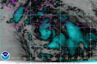
Shortwave IR figure of Issac at 11:45 PM EST, 2 hours before making landfall in Haiti


Several years ago, a team of Howard University faculty members worked on a proposal (which did not get invited to the competition) on why disasters occur after the Hurricane Katrina disaster.  There are two  forces at work:  humans and nature.  I purposely did not put nature first because nature is always at work.  But a disaster can be though of as a combination of unsafe human conditions and the occurrence of a natural hazard.   Unsafe human conditions take on many forms - such as unsafe living conditions, like living in a tent when you are facing tropical storm force winds, or it can be that you are extremely poor and have not the means to run from the natural hazard, or you could be elderly, very young, disable and not have the ability to address the oncoming hazard.    The natural hazard could be a hurricane, floods, droughts or earthquake.  While we cannot predict Earthquakes, we can predict many of the other hazards.  So why is there a disconnect between protecting the vulnerable?????

The answer is simple:  Decisionmaking

So how does this happen??? In the boo,  At Risk:  Natural Hazards, people’s vulnerability and disaster by Wisner and co-authors (2005) the suggest the following set of items are possible:
 
(a) a group may fail to anticipate the event ; 
(b) they may fail to perceive the crisis the when it arrives; 
(c) they may fail to act after perceiving it; 
(d) they may try and still fail. 

As for Haiti and Tropical Cyclone Issac, clearly items A and B were at work. 
Lets address point A:"

Point A group may fail to anticipate the event
Who is in this group?? Forecasters, government decision-makers, individuals that may be impacted.

 While the Hurricane Center had properly forecast the tropical storm, there were issues with intensity and also track all week.  When Issac should have intensified it did not, when it have gone northwest it went west and even south at time.  But the uncertainty means that many people (governments, individuals)  do not act in a proper manner.
Listening to CNN in the tent cities, many people did not seem to know that a natural hazard was nearly upon them, so they stayed in the camps and did not go to evacuation sites.  This is a failure of  government side to communicate.  However, given that more than 400,000 persons are in camps I am not sure about the ability to safely house 25% of the people.   In addition, while the government is working on new housing, it is playing a dangerous game of chance and the entire international community should be helping to build stronger shelters 2 years after the Earthquake.

So late yesterday when Issac began to get organized, it also took on a more northerly direction, which would make a more direct hit on areas that were vulnerable.  Somehow this information never seemed to sink in.  Stronger wind along with higher rain rates increases your vulnerability.   The pressure had been falling steadily all day with TC Issac and then an eye-like feature began to form between 10-11 EST.  The eye-like feature made land-fall along the Haitian coast at 2 AM at that point these should have been further action.

What amazed me was that they do not evacuate in Haiti to shelters until the storm is upon them-- it is raining and the wind is blowing.  Extremely faulty thinking regardless of how many times you have had false alarms.  Public safety is not a question of how you will be perceived or if you are liked because of your action.  It is a responsibility.

Point B
 they may fail to perceive the crisis the when it arrives;

In this case, if your communication system is damaged or down for a period of time, you lose a sense of what is happening around you.  You are thinking about the areas that always flood, but you have a blind spot because you have not been in this situation before.  So you think on Cholera, flash flooding but what about compromised tents with objects flying around at 40-50 mphs.  How do you get to people in need, if power or cell phones are not working, it is dark, there is still heavy rain falling and roads are not passable?   While all scenarios cannot be worked, many of them can be. 

But there is one real issue:  Do you care about the vulnerable?  Are they an embarrassment to you because they are poor?  Have you put them in a box where their live and livelihoods are less important than yours?  This is not an a guilty judgement on anyone but no matter where I have been (US, Canada, Africa), those at the bottom of the created social scales are perceived as being less-- they have no voice, no face and are not heard.  In a world where race matters, these are often people of color (Black, Brown, tan, yellow, red) with poverty stamped on their forehead. 

I can't help to wonder why these situations play out over and over again in this World with so much wealth.  Deep down inside maybe we want to run away from being vulnerable and protect ourselves with material wealth.  Maybe, we are too busy with our own lives to do anything about it.  Maybe there are too many channels on TV with so little relevant content so that we are misinformed.  Maybe we don't understand the scale of disaster.  Maybe we don't want to be bothered.

I don't know the answer, but disasters are knocking on the door in a changing climate.  Wildfires, droughts, floods, Katrina type events are going to impact all of us at some point whether we are rich or poor.

Haiti, in recent years has been perceived as corrupt, violent, impoverished and poorly governed.   But that does no justice to courage/strength of the people that first broke the system of slavery and French ruler-ship.  The Haitian population will always be perceived in the Diaspora and African continent as the fore-runners of independence and the fight for human dignity.  There is a price to pay for such an action.   You can work out the math for yourself....

I hope that there are no injuries or fatalities from TC Issac in Haiti.  I pray that parents can protect their children from the howling wind and heavy rain, but this one has all of the ingredients of a disaster:  Human + natural hazard.


Friday, August 24, 2012

Issac Intensifying tonite- Eye appears to be forming


Tonite, things seems be going from bad to worse for Haiti.  Over the last 5 hours Issac has been going through intensification and slowing down as it approaches Haiti.  The Hurricane Center will report the latest finding in 10-15 minutes.  The pressure has been falling all evening and to the east in the Dominican Republic, Barahona reported 50 MPH gust but they have not reported in nearly 3 hours.  There have been no hourly observations from Port Au Prince for about the last 4-5 hours.  As long as Issac remains off shore, it will likely intensify before going onto land. 

My reading based on Reports from CNN is that people are still in the tent cities.  I do not think that they will be able to stand up to strong tropical storm force wind for very long.  The heavy rain is also on the way.  Clearly not the best scenario developing tonight for Haiti.  The shortwave IR and now IR images show that a small eye seems to be developing.  Should be confirmed by aircraft over the next few hours.


Issac Organizes itself -- Haiti -- prepare for impact

Friday 8/24 11:45 Visible Image of Issac
Well, it looks like Issac after being disorganized with multiple centers and having a track that was south of the the Greater Antilles is making its move north.  It is organizing around a central center which was not obvious in the last 3-4 days.  Issac has increased from 45 MPH to 60 MPH since 5 AM this morning and appears to be strengthening while moving NW taking it on a track to intersect Haiti.  Based on its current motions, the weather should being to worsen in the next few of hours in Haiti.  Depending on the exact track, the Issac may not weaken much as it will may not interact with the mountains.   Residents should expect winds of 30-60 MPH with higher gust, but the rain will be extremely heavy with life-threatening flash floods in Port au Prince and northward to Gonaives.    The next 24 hours will be difficult.

There is still uncertainty on where this storm is going after it impacts Haiti and Cuba.  But no one should be at ease because Issac may be stronger and more organized than initially anticipated.  The cone of uncertainty is very large with land-fall anywhere from Florida to Louisiana by Wednesday.  There is even more uncertainty on how strong it will be at that point.   Now we must hope and pray for the people of Haiti to remain strong and for the impacts to be minimal.   But the time of trial is upon them.


Thursday, August 23, 2012

What's going on? Issac?


This morning, there is a much confusion about Issac as there is about the economy.  Where is the center of this storm?  This reminds me of Tomas in 2011 when it was unclear how the storm would evolve once it reached the Caribbean sea.  Issac has all of the good environmental conditions that should make it intensify and yet there has been no action -- nothing to write home about.  Over night the center of the storm seems to have moved south and the hurricane hunters are finding multiple centers of rotating air.  Well maybe there is still a lot to learn about hurricane intensity. 

There is still the feeling that the storm will impact Haiti sometime tomorrow and then move towards the northwest.  However the confidence in the track and intensity are not so high in my opinion. 

The other issue:  Focus.  There is more stories on how the republican convention might be disrupted by Issac than about how the population of Haiti will be disrupted.  There are hundreds of thousands of people in Haiti living in camps. CNN says 421,000 people.   The convention will be moved somewhere else and the loss of life will be minimal.  But for the people of Haiti, it is not possible to move anywhere except away from local dangers such as rivers that will overflow.  They cannot run from the wind or rain if Issac were to make landfall.  Even with the new houses that have been built by the government it is not enough to cover all of the people as it will take more time to provide shelter for many of those who survived the Earthquake.

In a strange way, the longer it takes for Issac to develop, the more dry air that is available and the longer it takes for the center to come together, the better for the people of Haiti.  They need more time to protect the vulnerable and rebuild houses and neighborhoods.  But this must happen quickly, because eventually a hurricane will strike Port Au Prince.

Haitan Camp in Port Au Prince (Washington Post)
I think that the ECMWF forecast has the right trend and that there may be a more westerly track to this storm.  Even that is uncertain, but everyone from Haiti, Cuba, Florida and the Gulf States need to be ready.  It is still too early in the hurricane season and pattern of high pressure over the Eastern and Central Atlantic has been pretty persistent over the last few months.  Later in September, the evolving El Nino should bring more shear and the frequency of troughs should help to steer some of these storms out to sea.  But uncertainty is in the air, we just have to live with it and stay vigilant.   No of us are in the clear -- even in Washington DC. 

Tuesday, August 21, 2012

TC Issac Reload


Tonight Tropical Storm Issac makes it way westward into the Caribbean.  Tomorrow it will begin impacting the islands.  This has been a very strange hurricane season.  We have named storms very early on (May and June).  We have had two hurricanes (Ernesto and Gordon).   Issac is a tropical storm and forecast to become a hurricane.  The storm track has been favoring the Caribbean sea, but there has also been so much dry air coming across the Atlantic from the Sahara and the storms have been moving fairly fast over the last couple of weeks.  Hence, thus far the storms have been nothing to write home about. 

This Issac reminds me of a time 6 years ago when its predecessor (Issac) was taking shape off the Guinea coast on about the 19th of September 2006.  The French Falcon aircraft was stationed in Dakar Senegal in the third phase of the Special Operations Period (SOP-3) of AMMA.  All of the forecast were suggesting development of a storm off the coast and I felt confident about it also.  The aircraft team went our suggestions and when they arrived there some 2 hours later -- nothing....  The disturbance was there in the wind field but not clouds, no developing cyclone... a waste of fuel.  Yeah I felt bad about it but it turns out that the disturbance did form much later over the Central Atlantic.  It evolved into a minimal hurricane over the Atlantic that posed a threat to no one.

But can we say the same for Issac that is about to enter the Caribbean Sea?  I don't think so.  It has been organizing itself slowly even with dry air to the north that has inhibited the storm from developing.  There is low shear over the Caribbean sea and the ocean temperatures are warm.  The track of the storm is carrying it toward Haiti.

However, there has not been lots of consensus on where this storm is going or its intensity.  In the short term they all seem to take it into near Haiti, but after the ECMWF model carries it towards western Cuba while some of the others carry it towards Florida.  The strength of the storm is also unclear, because if it does interact with Haiti (which I hope that it does not), the mountains will disrupt the circulation and weaken the storm.  It seems that the storms this year have been difficult to forecast at least in the early stages so we will stay tuned.    But in the meantime, we are ramping up into the heart of the hurricane season.  It is not a bad idea to check and make sure that you have your emergency kit and know where all of your important documents are located. 

You never know.....

Maybe Issac 2012 will outshine its 2006 predecessor

Wednesday, August 1, 2012

Dry air Impacts on Senegal Rain

So the question that we struggle with is how did this situation come about??  It is a bit technical, but anytime you have a factor that last more than a few weeks, there is a large scale pattern that is at work.  Below I have a few examples of satellite based rainfall movies of how the dry air near the coast is disrupting precipitating system.

Case 1 July 23-24


This is a line of convection that formed during the evening and moved towards the coastline.  Under normal conditions, this type of storm would definitely reach Dakar with heavy rain.  The opposite happens in this case where the observations show that dry air is locked in 200 meter.


Case 2 (Squall line from Mali
July 31 - August 1

In the second case, a relatively strong squall line came across Mali and entered eastern Senegal during the early morning hours.  At 0600 UTC (2 AM US east coast)  the picture show rain rates and the squall line entering eastern Senegal.  But the dry air is still locked in Senegal.  Here is the movie of the line today.


The good news is that even Dakar, did receive some rain this afternoon. But the situation
needs to be watched.